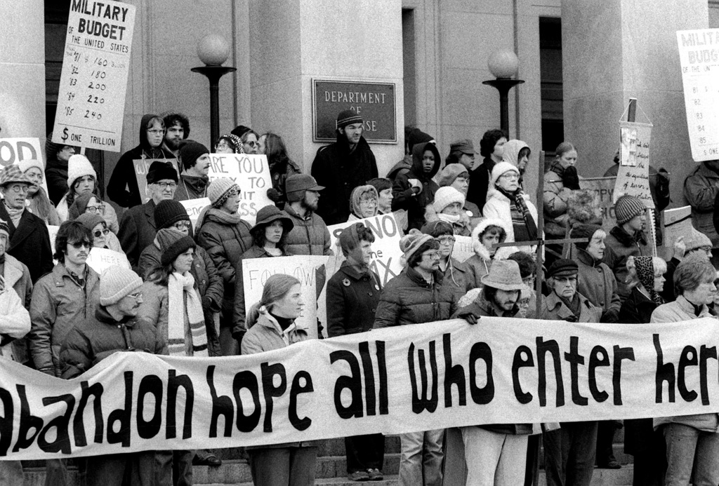


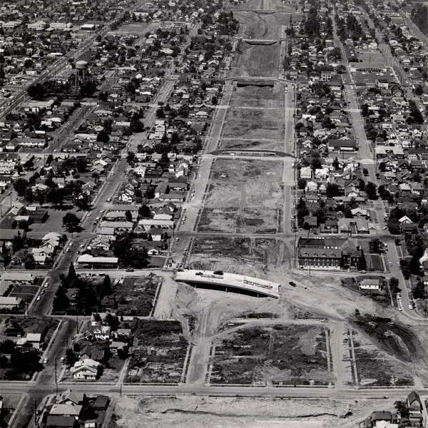
In the fall of 1966, the completed Interstate 5 (I-5) expansion opened, splitting Albina — a collection of historically Black neighborhoods in Portland — in two. The I-5 project, which was part of a series of “urban renewal” efforts in Portland during the 1950s and ‘60s, displaced hundreds of Black-owned businesses and families. I-5 divided the area into upper and lower Albina, and poured car traffic into the residential streets.
“This whole area is a concrete island,” says Ahlam Osman, a communications associate at Albina Vision Trust (AVT), an organization dedicated to rebuilding around 94 acres of land in lower Albina. “It’s a place for cars, and it’s very clearly been created as such,” adds Carly Harrison, senior vice president of real estate at AVT. The neighborhood is one of the most traffic–heavy in the state. The stretch of I-5 between I-84 and I-405 is the largest traffic bottleneck in Oregon, according to the Oregon Department of Transportation (ODOT).
Projects like the original I-5 development aren’t unique to Albina or Portland — rather, they’re a product of nationwide urban planning policies that prioritized car movement and split communities just like Albina across the country.
Dubbed “The Father of Parks and Traffic” by the New York Times in 1999, Urban Planner Robert Moses’ decades-long career during the early-to-mid 20th century was as controversial as it was infamous. Moses was the primary architect of the New York State Parkway system, along with the New York State Park system. He oversaw the development of multiple bridges and highways, totaling $27 billion worth of projects in 1968 dollar values, or around $250 billion today, according to “The Power Broker,” a Pulitzer-Prize winning biography of Moses.
“Robert Moses was kind of the highway king,” says Alan DeLaTorre, an adjunct professor at the Toulan School of Urban Studies and Planning at Portland State University, and a senior council aide for Portland City Councilor Tiffany Koyama Lane. “In the 1920s, we saw a pretty quick shift in the way that cities felt and were planned. For about 100 years, a lot of the United States moved toward an auto-centric paradigm.”
Although Moses led the development of New York City as we know it today, “The Power Broker” alleges his bridges and highways displaced around 500,000 predominantly Black and Latino New Yorkers. He became known for his heavy-handed approach towards public works. “You can’t make an omelet without breaking eggs,” he famously said in a speech. “When you operate in an overbuilt metropolis, you have to hack your way with a meat ax.”
As suburbs boomed post–World War II, and middle–class Americans moved out of cities, Moses’ vision of car dominance took hold across the country at all levels of government. Cars connected the growing suburbs, led by President Dwight Eisenhower’s Federal-Aid Highway Act of 1956, which linked the country by interstate highways, including I-5 and I-84.
“Part of it is the American idea of independence and individualism,” says DeLaTorre. In the 1950s, the individual automobile became a status symbol of the middle and upper classes in the United States, as well as a mode of transportation.
DeLaTorre says Moses’ “hacking” took away alternate modes of transit. “The ‘autoization’ of communities stripped away active transportation infrastructure,” he notes. Broadly, active transportation is any mode of transport that requires physical action, like walking, biking, or traveling to a public transit stop.
Back in Albina, AVT has been working with the city of Portland and ODOT to rebuild Albina with a focus on active transportation. Their efforts are seen in the I-5 Rose Quarter Improvement Project, a nearly $2 billion renewal initiative led by ODOT. While the project builds storm water facilities and expands I-5 to decrease traffic congestion, the plan also includes a highway cover from the corner of NE Tillamook St. and Flint St. south to NE Weidler St.. The cap would add seven new acres of land and restore the street grid of N Flint St., Vancouver St., and N Williams St., going north and south, and N Weidler St., Broadway St., Hancock St., and Tillamook St., going east and west, reconnecting Albina.
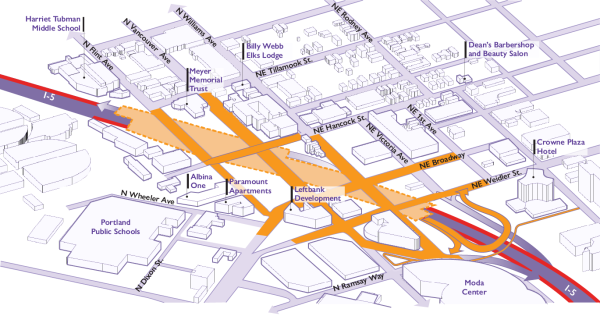
ODOT received $450 million in grant funding from the federal government in 2024, as a part of the Biden administration’s Reconnecting Communities Pilot Grant Program. A reconnected Albina is central to AVT’s transportation goals in the coming decades. “We don’t want to make this car-centric,” says Harrison. She notes that, though the Moda Center will draw cars no matter what, the rest of their plan for Albina is focused on pedestrians and cyclists. “We want everything to be very thoughtfully pro-pedestrian.”
By starting with the pedestrian, AVT prioritizes open public spaces and focuses its planning around the experience of the individual. “The [new] neighborhood is built around open space and the public realm,” she says.
Harrison says community has always been the driving force behind AVT’s work, and pedestrian–centric planning fuels that. “It provides a richness of life and an opportunity to connect with other humans on a day-to-day basis,” she says. “You get to know your neighborhood and your neighbors so much more.”
Currently, the I-5 Rose Quarter Improvement Project is in what Harrison describes as “little bit of a limbo,” after the Trump administration rescinded all federal funding for the project.
Across Portland, plans for active transportation and pedestrian-focused neighborhoods have been prioritized since as early as the 1980s and ‘90s. “Portland was a quick adopter of modern urban planning,” says DeLaTorre. The first Metropolitan Area Express (MAX) system lines were completed in 1986, and in June 1996, Portland adopted the Portland Bicycle Master Plan, adding 630 miles of bikeways within city limits.
Bike infrastructure is part of a larger method DeLaTorre calls “centers planning,” which attempts to make dense neighborhoods with everything a person needs within 15-20 minutes from their home. These denser neighborhoods disincentivize car usage, since most trips away from the home are walkable or bikeable. “Denser neighborhoods lead to higher transit ridership and bike ridership,” he says, noting that these “complete” neighborhoods are built around alternate modes of transportation.
For travelers going between neighborhoods, the city plans for “corridors” — high density, busy streets with public transit — that funnel travelers. Division St., which the Frequent Express (FX2) bus line goes through, is the main corridor in Southeast. Busy streets with no public transportation are called “main streets,” which Portland has few of. Mississippi Ave., in Northeast Portland, is one of the few “main streets” in East Portland.
By keeping traffic on main streets and corridors, DeLaTorre foresees bike ridership increasing. “It boils down to one basic tenet: people need to be safe and comfortable when they’re riding.” He says by diverging traffic and establishing “neighborhood greenways” — bike friendly throughways — people are more likely to engage with the biking infrastructure. The goal is to separate bikes and traffic as much as possible, with a few exceptions, such as Foster Rd. Foster is a traffic-heavy street that shares space with bikes between the car lanes and the curb.
However, since the COVID-19 pandemic, the City of Portland has struggled with increasing bike and transit ridership. The number of Trimet commuters plunged nearly 60% in 2021, and has struggled to return to its pre-pandemic high of 103.3 million yearly rides. Trimet is also facing line cuts in 2026, citing “ridership data” and a “56% increase in costs,” according to their website. Trimet did not respond to a request for comment.
Despite the challenges, DeLaTorre says Portland is moving in the right direction by focusing on building sustainably. Harrison has a similar outlook. “In the planning world, we often say that a project has to die seven times before it is completed in its final form,” she says. “In the nature of our work there will always be setbacks … but we don’t ever give up.”